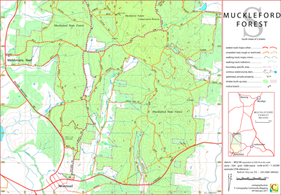
Muckleford Forest South Walking Tracks Map
The Muckleford Forest North map sheet contains the Red, White and Blue Mine
(DELWP notes,
Castlemaine Field Naturalists Club notes) and access routes from Newstead and Welshmans Reef.
It is probable that if you intend to use the Muckleford Forest South map sheet you will require the Muckleford Forest North map sheet also.
The intended hardcopy size for this map is A3.
Potential Confusions
There a JAMES TRK (north sheet) and a JAMIES TRK (crosses over sheets), however the southern end of JAMIES TRK is sign posted JAMES TRK.
MIA MIA TRK is a distinct branch off, not an extension of, MIA MIA RD.
There is confusion in sign posting and authority maps between SULLIVANS TRK and SPRING HILL TRK.
There is a SOUTH GERMAN TRK (south sheet) and a SOUTH GERMAN RD (north sheet).
SOUTH GERMAN TRK bifurcates at its northern end and hence is sign posted twice on BELLS LANE TRK.
The track immediately to the east of ROBERTS RD is signposted BELLS LANE TRK though shown on some authority maps as WELSHMANS REEF RD.
BLOW MINE TRK is in places signposted BLOWMINE TRK.
BUNDJALUNG TRK on some DELWP derived maps is shown as SCALLYWAG TRK (its original name).
Earliest Field Data and Updates
05/12/2016 – Earliest field data.
18/05/2017 – Increased minor track data south of the Pyrenees Highway and off SEC Dam Rd. and Blow Mine Trk.
16/06/2017 – Increased minor track data north-east of Welshmans Reef.
07/07/2017 – Increased minor track data to the north and west of the Red, White and Blue Mine.
22/07/2017 – Minor track detail (especially beween Spring Hill Rd and Bruces Trk) included. Map subtitle is now "Walking Tracks".
02/09/2019 – Increased overlap with North Sheet.
20/09/2022 – Cosmetic changes.
01/02/2025 – Frenchmans Reef added, cosmetic changes.
Muckleford Forest South Walking Tracks downloads.
| PDF file for printing at A3 (0.6 MB) | Download |
KMZ file (8 MB, 20 tiles) | Download |
| Some points of interest as GPX file (22 kB) | Download |
Listing of above POIs as PDF file (100 kB) | Download |
| OziExplorer file set (details) (< 8 MB) | Download |
GeoPDF file (insert not georeferenced) (< 3 MB) | Download |
The two POI files and the zipped OziExplorer file above are the same as those on the north sheet webpage.