CCM 
|
|
Caveat:
A map is a graphical representation of a geographical actuality. However, though some maps are more representative than others, no map is absolutely correct. The maps on this site are not exempt from this rule. |

CCM 
|
|
Caveat:
A map is a graphical representation of a geographical actuality. However, though some maps are more representative than others, no map is absolutely correct. The maps on this site are not exempt from this rule. |

The 60 zones are designated 1 — 60, bounded by meridians spaced at 6 degree intervals. (60 x 6 = 360) For example, Castlemaine lies in zone 55; Maryborough lies in zone 54 The zone boundary between zones 54 and 55 runs (north-south) between Baringup and Maldon. (People not familiar with Victorian geography perhaps could find their neighbouring zone-boundaries at Distribution Mapping Software.)
Eastings are the east-west component of a coordinate; northings are the north-south component of a coordinate. The units of eastings and northings are metre. Each UTM zone is divided into 20 lateral zones each of which is assigned an alphabetical zone character from C through to X excluding I and O.
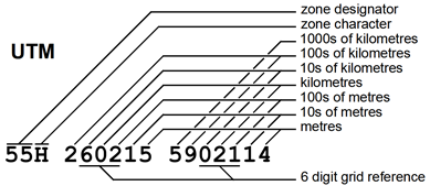
The diagram to the right shows the anatomy of a full UTM reference, 55H 260215 5902114 (the Mount Alexander Cairn).
The reference is formed from these components.

A 6 digit grid reference, 602 021 is formed from selected digits in the full reference. ('Rounding' may required in the determination of the easting and northing values.) A 6 digit grid reference has a resolution of 100 m and limited geographical coverage.
A grid reference system needs reference data, termed a datum. There are a large number of datums. The World Geodetic System 1984 datum, WGS84, is dominant internationally, however the Australian datum, GDA94, differs from WGS84 by less than a metre, so in normal practice the two datums are interchangeable.

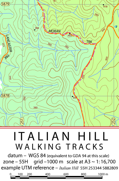
The notation on the eastings and northings is abbreviated– 3 trailing zeros are omitted. The complete specification of the western easting is 251000 (6 digits) and of the southern northing 5878000 (7 digits).
The zone information applies for the whole map. It is common for medium and large scale maps to be constructed within a single zone. The grid spacing of 1000 m is consistent with the grid notations. CCM maps often have awkward scales, this is a consequence of trying optimise the coverage and the resolution together with the mathematical reality that 10 has only two factors.
The sample UTM reference is provided so the user can check the coordinate format. A sample reference for this snip might be –
384 peak 55H 251134 5878724.
The 6 digit grid reference has an resolution of 100 m (the distance between adjacent references) and an uncertainty of 50 m (for border line cases). Dividing the distance between eastings (say) into half (0.5) and then, if need be quarters. (0.25, 0.75) can assist the estimation. A method that requires no estimation is to pick up the distance in question with pencil marks on the edge of a piece of paper and carry it down to the scale bar.
The "Humanitarian Field Guide to GNSS Technology" is a 7 page PDF document that covers GNSS basics, waypoints, tracks, scale, coordinate systems, and datums. It discusses the interaction of KMZ files, GPX files and GNSS data with Google Earth Desktop. Although principally directed to field humanitarian workers it may be of interest to technically inclined bushwalkers.