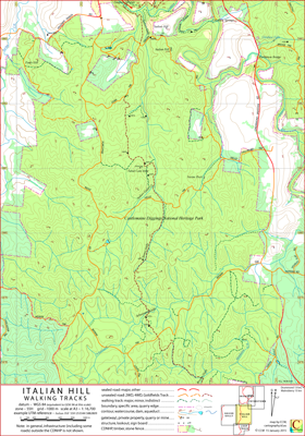
Italian Hill Walking Tracks Map
This map covers the area of the Castlemaine Diggings National Heritage Park containing Italian Hill, Victoria, Australia.
The Goldfields Track (this section of the track is common to the Great Dividing Trail and the Dry Diggings Track) passes through the area covered by the map.
Some of the notable features in the area are Vaughan Springs, Glenluce Springs, Glenluce Falls, Warburton Bridge, Porcupine Ridge Track, Italian Hill Track and Hunt's hut.
On its northern edge the map overlaps the Irishtown map, on its southern edge it is overlapped by the Loop Track map and on its eastern edge it overlaps the Shicer Gully map.
The intended hardcopy format (as PDF) for this map is A3.
Ambiguities and Uncertainties
There are two Sailor's Gully place names on this map, one in the north (a tributary to the Loddon River) and another approximately in the centre of the map.
There is a Hunt's hut (ruins) on this map, there is also a Hunt's hut (ruins) on the Loop Track map (references: Bushwalking Victoria, Richard Piesse, respectively).
Informed feedback about the naming of these huts is welcomed. Jase Haysom.
Helge Track at its east end is signposted and recorded on some maps as Helbe Track.
Earliest Field Data and Updates
27/05/2015 – Earliest field data.
09/09/2015 – Part of Lancaster Track included in southwest.
01/10/2015 – Some more detail in Tubal Cain Mine area included.
13/07/2018 – Glenluce Falls included.
03/10/2018 – Sanger's hut label, Hunt's hut (reference Bushwalking Victoria) included.
15/11/2018 – Track additions/adjustments in central region. (Thanks to John P. for input.)
02/10/2019 – Lancaster ruins included, minor track detail updated.
17/03/2020 – Siphon and falls included south of Bridge Track (552 826) (about 6 digit map references). Thanks to Jeremy H. for alerting me to these features.
Italian Hill Walking Tracks Downloads
| Single-sided PDF map for printing at A3 (< 500 kB) | Download |
KMZ file (< 10 MB, 20 tiles) | Download |
| Some points of interest as GPX file (< 10 kB) | Download |
Listing of above POIs as PDF file (< 50 kB) | Download |
| OziExplorer file set (details) (< 4 MB) | Download |
geoPDF file (< 2.5 MB) | Download |
Information on the utility of the additional files formats available above can be found in the Appendix panel of the header menu.