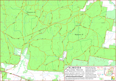
Almeida Walking Map
This map covers the southern component of the Waanyarra State Forest to the east of Dunolly, Victoria, Australia.
To the north it borders the CCM Waanyarra map.
The intended hardcopy format (as PDF) for the map is A3.
A (clickable on screen) A4 PDF file showing the locations of the 4 maps from the Waanyarra set is available.
Information on the use of the KMZ and GPX files below with GPS units and Google Earth can be found via the Appendix panel in the menu.
Track Classification
In dry conditions, it would be reasonable, for some tracks, to interpret the classification, "4WD", as "good ground clearance".
Potential Confusions
It is easy to misread "Brundles" on signposts as "Drundles". The spelling "Brundell's Paddock" has been transcribed from a notice on the gate at the southern end of the paddock.
The sign includes the notation "est 1867" There is a Pearces Road on the map, there is another Pearces Road off the map to the north-east.
This external Pearces Road provides access to the north-east corner of the mapped area. It may once have been contiguous with the Pearces Road in the mapped area.
Pan Track is labelled Dan Track on some maps
The name of the peak in the north-west – Reef Peak – has been invented (by CCM) for the convenience of reference.
It is common for the farm fences that mark the boundary between public and private land to have tracks been improvised for maintenance.
These tracks may be on the public side of the fence. Generally these tracks are not shown on the CCM map.
The pipeline is signposted "Water Pipeline". The service track besides the pipeline is unnamed. The spacing between the service track and the pipeline may have been shown, in parts, out of scale for clarity.
There are several "ruins" marked on the map. These ruins are small remnants of construction items or fire places,
Earliest Field Data and Updates
25/11/2023 – Earliest field data.
Resources Used in the production of this map
DEECA: preparation for field work, contours, water courses and infrastructure not in public forest.
Google Earth Pro Desktop: field work planning, timber coverage.
Field work: Road and track route and assessment, natural and constructed features.
Almeida Walking Map Downloads
| Single-sided PDF map for printing at A3 (< 0.4 MB) | Download |
KMZ file (< 6 MB, 20 tiles) | Download |
| Some points of interest as GPX file (< 14 kB) | Download |
Listing of above POIs as PDF file (< 120 kB) | Download |
| OziExplorer file set (details) (< 3 MB) |
Download |
Geo-PDF file (< 2 MB) | Download |
Information on the use of KMZ, GPX and OziExplorer files available above can be found via the Appendix panel in the header menu.