|
CCM |
|
Page Content:
Not all CCM graphical work is the production of topographical walking maps. |
Fo l i o
Mi s c e l l a n e a
Site Content

|
CCM |
|
Page Content:
Not all CCM graphical work is the production of topographical walking maps. |
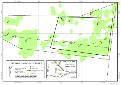
The map on the right is one of five prepared for the Upper Spring Creek Landcare Group the members of which are maintaining bush stone-curlew reserves as part of a reestablishment project. The map was prepared from GPS based field work, DELWP data and Google Earth data.
A realistic absolute uncertainty figure for such a map would be 5 metre. However the relative uncertainty can be tighter. For example the location of nesting box 2J would have been determined as just south of the dilapidated fence line when field observations were made. Without this observation, as a consequence of the 5 metre uncertainty value, the placement of the box relative to the fence (to the north or south) would have been in doubt.
The header image for this page was captured with a motion sensitive camera maintained by Frank and Jenny Steele, Upper Spring Creek Landcare Group.
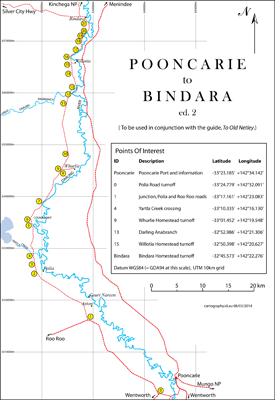
Each Australian state seems to handle its maps differently. Victoria produces digital maps; NSW hard copy maps. The map on the right was made by the tracing technique from scanned portions of two NSW Land Information Centre 1:100,000 maps. Edition 2 was checked against Google Earth images (again using tracing) and modified for closer alignment. Pooncarie to Bindara as a KMZ file.
Some points of interest (POI) (those listed on the map) are available as a KMZ file (for displaying on Google Earth) or as a GPX file (for loading into a GPX enabled device).
Material on this map may be outdated.
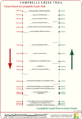
Imagine a bug being swept along in a narrow pipe full of flowing water. This pipe has regularly spaced markers (perhaps small windows) distributed along it. The intelligent bug can determine its position (referred to the start position) by counting markers. The bug's only concept of the world is a single value, its position along the pipe – it has no concept of left or right and up or down. It is unaware of sweeping curves in the pipe – it lives in a one dimensional world. Never-the-less when reporting on its trip the bug can provide useful information, "There is a fracture developing at 214.4 metre and the 300 window is clouding over, I nearly missed it."
The one dimensional map is structured to work for a user travelling from Forest Street to the Campbells Creek Park (coded red) and in the other direction (coded green). In each case the start is referenced as 0.00 km and progressive distances to track features are provided.
Work is preceding with the aim of finding a substantive application for this map.
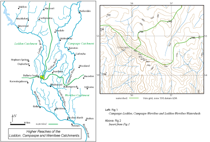
The Whirrakee is the monthly newsletter of the Bendigo Field Naturalists Club (www.bendigofieldnaturalists.asn.au/). The illustrations on the right were prepared as a single page 'print ready' for the Whirrakee. Fig 1 was 'traced' over a scanned image from a Victoria road atlas. Fig 2 was derived from DELWP data.
The Map.The article associated with the images was published in Whirrakee May 2011 Vol. 32 No. 4. Unfortunately back copies of the Whirrakee are not available online, however this is the text of the article.
Fig 2 is also available as a georeferenced KMZ file (693 kB).
Incidentally when producing a map for an academic paper I made KMZ formatted versions of the Earth appendix Victoria 1:500,000 geological map (1999) (West Victoria) (available via Energy and Earth appendix).
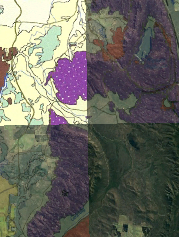
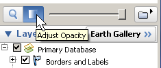
KMZ maps can be opened in Google Earth where they will overlay terrestrial features. The transparency (or its complement, opacity) of a Google Earth map image can be controlled with the slider at the base of the "Places" box in the sidebar and thus map features can be compared with on the ground features.
The image to the right shows four levels of opacity. In top-left section the map is completely opaque so the satellite image is hidden. The bottom-right is shows zero opacity, that is, full transparency. The other two sections show intermediate levels.
Some map capable GPS units will load KMZ files such as the Poonarie to Bindara example – refer to MapToGround appendix for more information.
There are three KMZ versions of the Earth appendix Victoria geological map available – take care to check the file sizes before downloading.
| Low-resolution KMZ file. (6.2 MB) | Download |
| Medium-resolution KMZ file. (24 MB) | Download |
| High-resolution KMZ file. (78 MB) | Download |
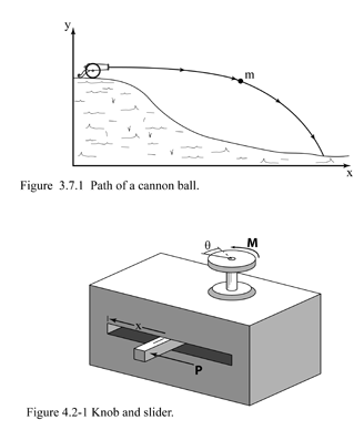
On request of the author I prepared a number of illustrations for a book on energy published mid 2017 by Oxford University press. Two of the illustrations are shown here. The upper one (the parabolic flight of a mass with an initial horizontal velocity) was displaced by an earlier more prosaic version, however, the lower one (dealing with that very useful concept, the principle of virtual work) was included.