Railway Dam Walking Tracks Map
This map covers the northern part of the Fryers Ridge State Forest to the west of Elphinstone, Victoria, Australia.
It includes the route of the ParksVic "Junction Walk", part of the Poverty Gully Channel, Railway Dam and northern sections of Railway Dam Road and Tunnel Hill Track.
It overlaps the CCM maps The Monk to the west and Fryers Ridge to the south.
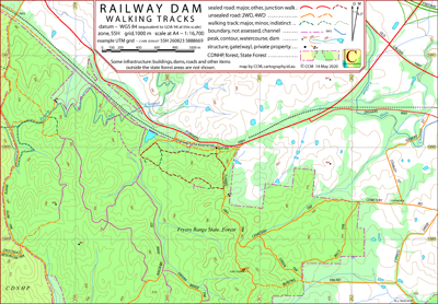
Why the name Junction Walk? "To the south of the railway line, between the tunnel entrance and bridge, was an early settlement called the Junction.
The original main gold route to the Diggings went through there, and then cut across to Expedition Pass Reservoir (then known as Golden Point)". — David Bannear.
The railway works in the vicinity of the junction are itemised in the Victorian Heritage Database Report: Elphinstone Railway Precinct.
The intended hardcopy format (as PDF) for the map is A4.
Information on the use of the KMZ and GPX files below with GPS units and Google Earth can be found in the Appendix panel of the header menu.
Earliest Field Data and Updates
06/05/2020 – Earliest field data.
Resources Used in the production of this map
DELWP: preparation for field work, contours, water courses, channels, infrastructure not in public forest.
Google Earth Pro Desktop: field work planning, timber coverage.
Field work: Road and track route and assessment, natural and constructed features, some channel detail.
Railway Dam Walking Tracks Downloads
| Single-sided PDF map for printing at A4 (0.8 MB) | Download |
KMZ file (4.5 MB, 12 tiles) | Download |
| Some points of interest as GPX file (2 kB) | Download |
Listing of above POIs as PDF file (30 kB) | Download |
| OziExplorer file set (details) (< 4 MB) | Download |
GeoPDF file (< 2.5 MB) | Download |
Information on the use of KMZ, GPX and OziExplorer files available above can be found in the Appendix panel of the header menu.
