Rise and Shine Bushland Reserve Walking Tracks Map
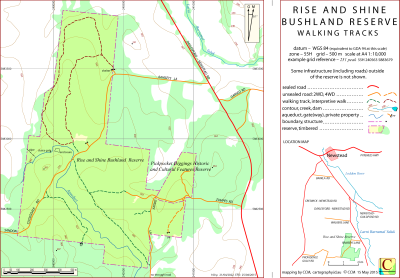
This map covers the Rise and Shine Bushland Reserve and the adjacent Pickpocket Diggings Heritage and Cultural Features Reserve several kilometres south of Newstead, Victoria, Australia.
There is a self-guided interpretive walk of about 3.5 km in the reserve and information leaflets are available in a box at the Ramsey's Lane entrance.
The intended hardcopy format (as PDF) for the map is A4.
It can be formed as a leaflet format by folding the left edge of the sheet forward to the guide marks between the main map and title section and then folding that section back.
Information on the use of other files provided by CCM can be found in the Appendix panel of the header menu.
Updates
25/04/2015 – Error in legend corrected – 'A3' replaced by 'A4'.
26/06/2017 – Contour text error corrected.
21/04/2022 – Jim Crow Creek renamed to Larni Barramal Yaluk. application pending.
(11/05/2023 – Name change above approved by the Office of Geographic Place Names.
Rise and Shine Reserve Walking Tracks Downloads
| Single-sided PDF map for printing at A4 (0.2 MB) | Download |
| KMZ file (2.5 MB, 12 tiles) | Download |
| Some points of interest as GPX file (2 kB) | Download |
| Listing of above POIs as PDF file (30 kB) | Download |
| OziExplorer file set (details) (< 1 MB) | Download |
| GeoPDF file (< 1.5 MB) | Download |
Information on the use of KMZ, GPX and OziExplorer files available above can be found in the Appendix panel of the header menu.
