CCM 
|
|
Caveat:
A map is a graphical representation of a geographical actuality. However, though some maps are more representative than others, no map is absolutely correct. The maps on this site are not exempt from this rule. |

CCM 
|
|
Caveat:
A map is a graphical representation of a geographical actuality. However, though some maps are more representative than others, no map is absolutely correct. The maps on this site are not exempt from this rule. |

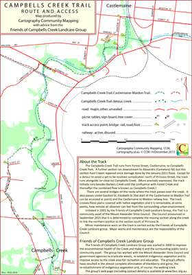
The Campbells Creek Trail runs from Forest Street, Castlemaine, to Campbells Creek Park, Campbells Creek. The track runs alongside (or close to) Campbells Creek. (More precisely expressed, the track initially runs besides Barkers Creek until the confluence with Forest Creek and thereafter the combined flow is known as Campbells Creek.) There are several bridges on the route where the track passes over the creek or under roads and the Castlemaine Maldon railway line. The track crosses flood plains covered with native vegetation and it is remarkable, at some points, how remote an observer can feel from the urban environment to the east.
The track surface is generally excellent and of low gradient. The track has many access points along it so there is the opportunity for planning interesting routes. There is access to the start of the Castlemaine to Maldon Trail at the Elizabeth St bridge. (Take care if making an arrangement to meet someone, there is an Elizabeth Street in the north and another in the south.) The track finishes at the Campbell Creek Park on Main Road.
The intended hardcopy format for the map is A4.
 Alternative Map Presentation
An alternative presentation of Campbells Creek Trail data using an experimental one dimensional presentation is available on the Folio Miscellanea page.
Almost all the map data were simply obtained by field work. The formal roads on the map were sourced from Mapshare and auxilary material was provided by Friends of Campbells Creek. Tree coverage and miscellanous detail was taken from Google Earth.
02/12/2015 – Earliest field data.
28/01/2016 – Access point at Camp Crescent included. Minor detail changes.
06/10/2016 – Minor detail changes.
10/01/2019 – Minor detail changes, start of Castlemaine to Maldon Trail included.
08/04/2025 – New section of trail eliminating detour included. The text content on the map has been reduced to provide space for more map detail, including the access points for the Leanganook Track and Dry Diggings Track sections of the GDT.
| Single-sided PDF map for printing at A3 (< 0.4 MB) | Download | KMZ file (< 3 MB, 12 tiles) | Download |
| Some points of interest as GPX file (< 5 kB) | Download | Listing of above POIs as PDF file (120 kB) | Download |
| OziExplorer file set (details) (< 2 MB) | Download | Geo PDF file (< 1 MB) | Download |