Kalimna Park Walking Tracks Map
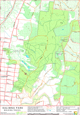
Kalimna Park, part of the Castlemaine Diggings National Heritage Park, is adjacent to the east edge of Castlemaine, Victoria, Australia.
Kalimna Point is in the southern part of the park and accomodates a Castlemaine Field Naturalists Club documented walking track.
The northern part of the park (it has a slightly more remote ambience) holds the Unknown Miners Grave. Just outside the park, to the south, is the Bourke and Wills Monument.
The intended hardcopy size for this map is A3.
In the park the distinction between a lightly used track and a heavily used animal pad can be unclear; also some of the shorter tracks could be reasonably classified as improvised shortcuts.
The cartographer has made subjective judgements on the inclusion or non-inclusion of some of the minor tracks.
Acknowledgements
The Friends of Kalimna Park assisted with the construction of the Kalimna Park Walking Tracks Map. Thanks also to George Milford,
Harcourt Valley Heritage and Tourism Centre, and Ern Perkins, Castlemaine Field Naturalists Club, for their input.
Earliest Field Data and Updates
27/08/2014 Earliest field data.
15/12/2014 Minor cosmetic changes, additional navigation content to the east of Colles Road included.
31/10/2018 Some minor updates to tracks north of golf course, ruins in north section added, cosmetic changes.
31/10/2018 Minor reclassification of some tracks in northern section.
Further Kalimna Park information
The Friends of Kalimna Park are keen to have more friends join their group.
The Castlemaine Field Naturalists Club has brochures on walks in Kalimna Park and Castlemaine.
These PDF formated brochures can be downloaded and printed at A4.
Kalimna Park Walking Tracks Downloads
Information on the use of KMZ and GPX files available above with GNSS units and Google Earth can be found in the Appendix panel of the header menu.