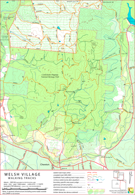
Welsh Village Walking Tracks Map
This map covers the area of the Castlemaine Diggings National Heritage Park to the north of Chewton, Victoria, Australia.
The Goldfields Track (this section of the track is common to the Great Dividing Trail and the Leanganook Track) passes through the area covered by the map.
Some of the notable features in the area are the Garfield Water Wheel, the Welsh Village, Sailors Gully, Manchester Reef and Forest Creek.
On its western edge the map overlaps the Kalimna Park map; on its southern edge the map is overlapped by The Monk map.
The intended hardcopy format (as PDF) for this map is A3.
Ambiguities and Uncertainties
Quartz Hill Track is also known as Quartz Hill Road (it is signposted so at the west end). The distinction is most likely social. The northern extent of the name "Garfield Track" is not currently defined.
Earliest Field Data and Updates
05/11/2014 – Earliest field data.
2015 – Some additional navigation content to the south of the Pyrenees Highway included. Further track detail near Expedition Pass Reservoir. Detail changes in Chewton. Chewton CFA shed included in POI files.
Minor notation and cosmetic changes.
2016, 2017, 2018 – Southernmost pine plantation removed to match changed on the ground conditions. Bald Hill and Elephant Hill notation added. Additional POI (Deadmans Gully Cemetery) included.
Minor detail and cosmetic changes.
17/06/2020 – Additional: walking tracks (563-938, 510-932), dam (566-935), ruins (575-946, 565-944, 569-953, 570-931), in-ground chimney (570-931), adit (570-934). POI updates.
22/12/2021 – Accumulated detail updates.
22/12/2021 – General update of Garfield Wheel and Whelsh Village regions principally in response to Parks Victoria's work on establishing designated walking tracks and using gates to manage vehicle access to tracks.
The original data on this map dates back to late 2014 and some tracks have been categorized downwards as a result of understory growth.
Welsh Village Walking Tracks Downloads