Loop Track Walking Tracks Map
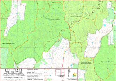
This map covers the southern area of the Castlemaine Diggings National Heritage Park containing Loop Track, Victoria, Australia.
The Goldfields Track (this section of the track is common to the Great Dividing Trail and the Dry Diggings Track) passes through the area covered by the map.
Some of the notable features in the area are Browns Gully, Tarilta Creek, Hunt's hut and Loop Track. On its northern edge the map overlaps the Italian Hill and Shicer Gully maps.
The intended hardcopy format (as PDF) for this map is A3.
Ambiguities and Uncertainties
The road running north off Limestone Track (502 773) is signposted Shicer Track; it appears on other resources as Rusconis Road and Shicer Gully Road.
There is a Hunt's hut (ruins) [Richard Piesse] on this map, there is also a Hunt's hut (ruins) [Bushwalking Victoria] on the Italian Hill map.
Informed feedback about the naming of these huts is welcome. Jase Haysom.
Amanda's Track is signposted at the west end (528 768). It is not referenced on resources to hand. However, the Castlemaine Diggings National Heritage Park Management Plan
refers to the "Amanda's Track Network" – a reasonable name for the tracks to the east of the "Amanda's Track" signpost.
There is a signpost "Links Track" where the Goldfield Track crosses Loop Track (527 769). CCM does not know to which track this sign refers.
Earliest Field Data and Updates
03/07/2015 – Earliest field data (as A4 version).
03/10/2018 – Hunt's hut (reference Richard Piesse) labelled. Cosmetic adjustments.
03/03/2020 – Map expanded to A3. Tarilta Falls included.
Loop Track Walking Tracks Downloads
| Single-sided PDF map for printing at A3 (< 0.5 MB) | Download |
| KMZ file (< 10 MB, 20 tiles) | Download |
| Some points of interest as GPX file (4 kB) | Download |
| Listing of above POIs as PDF file (< 100 kB) | Download |
| OziExplorer file set (details) (< 4.5 MB) | Download |
| GeoPDF file (< 3.2 MB) | Download |
Information on the use of the file formats available above can be found in the Appendix panel of the header menu.