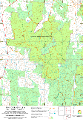
Shicer Gully Walking Tracks Map
This map covers the area of the Castlemaine Diggings National Heritage Park, CDNHP, containing Shicer Gully, Victoria, Australia.
The Shicer Gully part of the CDNHP stands as an island to the rest of CDNHP.
On its eastern edge the map overlaps the Italian Hill map; its southeast corner overlaps the Loop Track map.
Although the maximum elevation at approximately 406 metre is about the same as that in, say, the Italian Hill area, because of the low land to the southwest the general impression of height is more marked along,
for example, the southern section of Steep Trk and the unnamed walking track in the east of the park.
The intended hardcopy format (as PDF) for this map is A3.
Ambiguities and Uncertainties
The names Shicer Gully Road and Rusconis Road are used (on signposts and on maps) interchangeably.
Sign posts indicate a distinction between Pound Lane and Pound (Lane) Track.
Earliest Field Data and Updates
05/08/2015 – Earliest field data.
17/09/2015 – Track detail in southwest region of map included.
01/10/2019 – Lancaster ruins included, State Forest areas indicated.
Shicer Gully Walking Tracks Downloads
| Single-sided PDF map for printing at A3 (0.4 MB) | Download |
| KMZ file (9.2 MB, 20 tiles) | Download |
| Some points of interest as GPX file (5 kB) | Download |
| Listing of above POIs as PDF file (33 kB) | Download |
| OziExplorer file set (details) (< 4 MB) | Download |
| GeoPDF file (< 2.2 MB) | Download |
Information on the use of KMZ and GPX files available above with GPS units and Google Earth can be found in the Appendix panel of the header menu.