Nuggetty Gully Walking Map
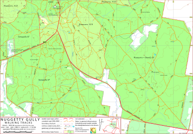
This map covers the south-eastern component of the Waanyarra Nature Conservation Reserve between Tarnagulla and Laanecoorie, Victoria, Australia.
It also covers the Waanyarra-Dunolly State Forest and parts of the Tarnagulla State Forest.
To the north it borders the CCM Tarnagulla map and to the west it borders the Waanyarra map.
The intended hardcopy format (as PDF) for the map is A3.
Information on the use of the KMZ and GPX files below with GPS units and Google Earth can be found via the Appendix panel in the menu.
Track Classification
Why a walking tracks map without any walking tracks? On the ground there are no walking tracks, there are just varying degrees of vehicular tracks.
Putting aside the sealed roads the main tracks (and a couple of roads) are 'formed', that is, the tracks have been surfaced with additional material and graded.
The remaining tracks have come into existence by repetition of use, and vary from well defined to barely discernable – a walker can take her pick.
On much of the mapped area the understory is slight enough that it would be feasible for a party with appropriate navigation skills to travel across country.
In general, in dry conditions, it would be reasonable to interpret the classification, "4WD", as "good ground clearance".
Potential Confusions
On maps and in the field the names Paddy Track and Paddys Track are used interchangeably.
On maps and in the field the names Butler Track and Butlers Track are used interchangeably.
Nuggety Creek is spelt with a single 't'.
The track that connects Waanyarra Road to the southern end of Tarnagulla Track is sign posted as Jude Track but is labelled as Mortons Track East on some DELWP maps.
Earliest Field Data and Updates
10/03/2022 – Earliest field data.
11/03/2023 – Minor changes to accomodate introduction of CCM Tarnagulla map.
26/09/2023 – Minor changes to accomodate introduction of CCM Waanyarra map. Geo-PDF file replaces Geo-TIFF.
Resources Used in the production of this map
DELWP: preparation for field work, contours, water courses and infrastructure not in public forest.
Google Earth Pro Desktop: field work planning, timber coverage.
Tarnagulla.com: Historic information.
Field work: Road and track route and assessment, natural and constructed features.
Nuggetty Gully Walking Map Downloads
| Single-sided PDF map for printing at A3 (0.4 MB) | Download |
KMZ file (6 MB, 20 tiles) | Download |
| Some points of interest as GPX file (14 kB) | Download |
Listing of above POIs as PDF file (120 kB) | Download |
| OziExplorer file set (details) (< 3 MB) |
Download |
Geo PDF file (1.5 MB) | Download |
Information on the use of KMZ, GPX and OziExplorer files available above can be found in the Appendix panel of the header menu.