Tarnagulla Walking Map
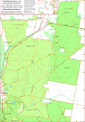
This map covers the north-eastern component of the Waanyarra Nature Conservation Reserve between Tarnagulla and Llanelly, Victoria, Australia.
It also covers the Llanelly State Forest west of Newbridge, Victoria Australia. To the south it borders the CCM Nuggetty Gully map.
The location of Bell's Cottage, the Yorkshire Mine and the region of the Corfu Mine are indicated on the map.
The intended hardcopy format (as PDF) for the map is A3.
A (clickable on screen) A4 PDF file showing the locations of the 4 maps from the Waanyarra set is available.
Information on the use of the KMZ and GPX files below with GPS units and Google Earth can be found in the Appendix panel of the header menu.
Track Classification
In general, in dry conditions, it would be reasonable to interpret the classification, "4WD", as "good ground clearance".
Potential Confusions
There almost a total absence of signage. This is a result of very few tracks actually having names.
Near the Tarnagulla township and to the south, near the highway, the proliferation of tracks makes it impractical to map all tracks.
Earliest Field Data and Updates
23/03/2022 – Earliest field data.
28/09/2023 – Geo-PDF file replaces Geo-TIFF. Minor cosmetic adjustments.
Resources Used in the production of this map
DELWP: preparation for field work, contours, water courses, infrastructure not in public forest.
Google Earth Pro Desktop: field work planning, timber coverage.
tarnagulla.com: Historic information.
Field work: Road and track route and assessment, natural and constructed features.
Tarnagulla Walking Map Downloads
| Single-sided PDF map for printing at A3 (< 400 kB) | Download |
KMZ file (< 6 MB, 20 tiles) | Download |
| Some points of interest as GPX file (< 14 kB) | Download |
Listing of above POIs as PDF file (< 120 kB) | Download |
| OziExplorer file set (details) (< 3 MB) |
Download |
Geo_PDF file (< 2 MB) | Download |
Information on the use of KMZ, GPX and OziExplorer files available above can be found in the Appendix panel of the header menu.