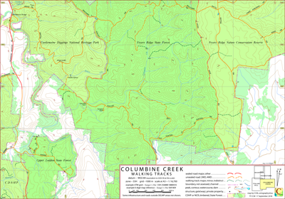
Columbine Creek Walking Tracks Map
This map covers portions of the Castlemaine Diggings National Heritage Park, Fryers Ranges State Forest, Fryers Ridge Nature Conservation Reserve and Upper Loddon State Forest. Victoria, Australia.
Some of the features in this area are the entire length of Columbine Creek and Salters Creek, Glenluce Falls, Warburton Bridge and Sanger's hut.
On its western edge the map is overlapped by the Irishtown map; on its northern edge it is overlapped by the Fyerstown map and on its northeast corner it overlaps the Fryers Ranges map
(note, the Fryers Ranges map is not a member of the CDNHP series).
The intended hardcopy format (as PDF) for this map is A3.
Potential Confusions
Old Hunter's Ln is recorded on DELWP maps but is signposted as Hunters Trk. The road exiting the map south near the 258000 easting is signposted Hunters Ln.
Earliest Field Data and Updates
12/09/2018 – Earliest field data.
17/03/2020 – Siphon and falls included south of Bridge Track (552 826) (about 6 digit map references).
Siphon and ruins included south of concrete ford in Hunters Trk (562 805). Thanks to Jeremy H. for alerting me to these features.
Resources accessed in preparing the Columbine Creek map
With the exception of the full length of the Drummond-Vaughan Rd CCM has walked all the roads and tracks on this map. Other data sources are:
Vagabond: the story of Charles Sanger, Auth: B. Slattery, D. Ralph, D. Slattery, Maps: J Waddingham, Pub:
Friends of the Box Ironbark Forests, 2008
DELWP
Mapshare (road and track data to be developed, cadastre),
Victorian Government Data search (contours, water courses),
Google Earth (timber coverage).
Columbine Creek Walking Tracks Downloads
| Single-sided PDF map for printing at A3 (0.5 MB) | Download |
Some points of interest as GPX file (2 kB) | Download |
| KMZ file (9.5 MB, 20 tiles) | Download |
Listing of above POIs as PDF file (< 50 kB) | Download |
| OziExplorer file set (details) (< 4.5 MB) | Download |
GeoPDF file (3 MB) | Download |
Information on the use of the file formats available above can be found in the Appendix panel of the header menu.