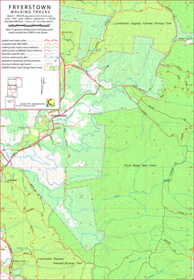
Fryerstown Walking Tracks Map
This map covers the area of the Castlemaine Diggings National Heritage Park to the west of Fryerstown, Victoria, Australia.
Some of the features in this area are Fryerstown, Irishtown, Fryerstown Cemetery and Glenluce Falls. The Fryers Ranges map is not part of the CDNHP series.
On its western edge the map is overlapped by the Irishtown map; on its northern edge it is overlapped by The Monk map; on its eastern edge it overlaps the Fryers Ranges map
and its southwest corner is overlapped by the northeast corner of the Italian Hill map.
The intended hardcopy format (as PDF) for this map is A3.
Potential Confusions
Smuttas Trk is (broadly speaking) 'U' shaped with both ends terminating at Irishtown Trk. Only the west end is signposted (as at 16/03/2020).
Roads within this region, may be, in different circumstances, referred to by a local name eg Old Coach Rd or a geographic name, eg the Fryerstown Rd.
Earliest Field Data and Updates
09/07/2018 – Earliest field data.
17/03/2020 – Siphon and falls included south of Bridge Track (552 826) (about 6 digit map references). Thanks to Jeremy H. for alerting me to these features.
08/12/2020 – Addition of two dams north of Herons Reef.
03/02/2021 – Addition of tracks and slate quarries in region accessible via Landseer St, Fryerstown. Thanks to Steve C. for alerting me to these features.
Resources accessed in preparing the Fryerstown map
The principal resource is simply boot leather; if a road or track within the Fryers Ranges State Park or the CDNHP is indicated then CCM has walked it. Other data sources are:
Fryerstown Walking Tracks Downloads
| Single-sided PDF map for printing at A3 (0.5 MB) | Download |
KMZ file (9.5 MB, 20 tiles) | Download |
| Some points of interest as GPX file (2 kB) | Download |
Listing of points of interest as PDF file (< 50 kB) | Download |
| OziExplorer file set (details) (< 4.5 MB) | Download |
Geotiff file (32 MB) | Download |
Information on the utility of the additional files formats available above can be found in the Appendix panel of the header menu.